
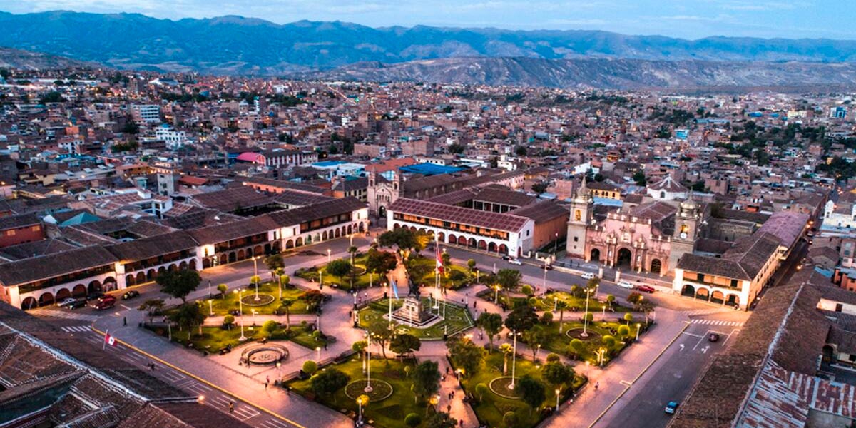
Ayacucho is one of the most fascinating destinations in Peru, where history, tradition, and natural beauty intertwine. Located in the south-central highlands, this city stands out for its colonial architecture, its religious festivals, its folk art, and its Andean landscapes that captivate every traveler.
The city of Ayacucho has one of the most notable architectural and artistic collections in Peru, it is known as the "city of the 33 churches" for its colonial temples and as the "lordly city" for its architecture, art and tradition. It also offers archaeological treasures, such as Wari and Vilcashuaman, as well as natural routes that connect with waterfalls, lagoons, and mountains.
Did you know that?... Ayacucho is also known because there is a tradition in the city that all houses must have a small church.
Ayacucho has an average altitude of 2,761 meters above sea level (masl). The department is located in the south-central part of the country, straddling the Peruvian Andes Mountains. However, its altitude varies depending on the district and its proximity to the Andes, varying between inter-Andean valleys, punas, and a tropical rainforest.
The department is crossed by both the Andes and the Ampato Mountains. Its soaring peaks and volcanoes make it one of the highest snow-capped mountain ranges in Peru. Some of its notable geographical variations are as follows:
The city of Ayacucho has a dry, temperate, inter-Andean valley climate, with an annual average of 15.4°C. However, it has extremes that range from highs of 26.5°C in November to lows of 7°C mid-year (June and July).
Its vast surface area of 43,814.80 km2 and its variety of regions give Ayacucho a rich climatic diversity. The jungle regions have warmer average temperatures, while the Andean punas reach much lower extremes. If we look at some of the department's largest cities, we can appreciate and compare their variety:
San Miguel (La Mar) | Huanta (Huanta) | Puquío (Lucanas) | Cangallo (Cangallo) | Vilcashuaman (Vilcashuaman) | |
Altitude | 2,661 m.a.s.l. | 2,627 m.a.s.l. | 3,214 m.a.s.l. | 2,577 m.a.s.l. | 3,490 m.a.s.l. |
Average maximum temperature | 26.4°C (November) | 25.9°C (November) | 20.8°C (November) | 25.8°C (November) | 20.7°C (November) |
| Average annual temperature | 16.4°C | 15.9°C | 10.9°C | 15.7°C | 10.8°C |
| Average minimum temperature | 5°C (June) | 4.4°C (June) | 5.1°C (June) | 4.4°C (July) | -0.5°C (July) |
During the austral summer, Ayacucho has its most intense rainy season. January is the rainiest month, with precipitation on almost every day of the month. Even so, the climate can be very variable: strong downpours alternate with periods of sun. In November, at the end of spring, temperatures can reach up to 29 °C, making it one of the warmest months of the year.
Winter is characterized by a dry cold with average temperatures of 13 °C. The days are usually sunny, but the nights can drop to 2 °C. In this season, the Los Libertadores Route can have snowfall in its highest sections, which sometimes causes road closures. June and July are the coldest months, ideal for enjoying clear skies and constant sun.
Although you can visit all year round, the dry season (June to September) is the most recommended, since the good weather allows you to explore attractions like the Pampa de la Quinua, Vilcashuamán, Pumacocha or the Pampa Galeras National Reserve without the limitations of the rain.
Ayacucho is known for its radiant sun almost every day of the year, even in the middle of the rainy season. However, due to the altitude, it is advisable to walk calmly and take precautions against soroche (altitude sickness). A local tradition to combat it is to drink a coca tea, an infusion that has accompanied the huamanguinos since ancient times.

Getting to Ayacucho from Lima by air or land is easy, and daily departures are available. Tickets cost between 35 and 110 soles for the Lima-Huamanga route, depending on the date and the ground transportation company chosen. The bus trip takes an average of 10 hours, so it is recommended to travel at night and sleep in to arrive well-rested.
The average altitude in Ayacucho is 2,800 meters above sea level. It is important to take precautions against altitude sickness and avoid excessive physical exercise upon arrival.
The climate is typical of the mountains: dry and temperate, with high temperatures of 26°C and lows of 9°C. It is sunny and hot between 10 a.m. and 10 a.m. and 6 p.m., while at night and in the early morning it is cold and freezing. Therefore, you should bring light clothing for tours or sightseeing, and warm clothing, such as a raincoat and windbreaker, for overnight stays or exploring open spaces.
Easter events are massive and last up to 10 days. It is recommended to purchase your ticket in advance if you plan to travel during these dates.
Peru offers unique experiences that show impressive landscapes, archaeological sites, and living traditions, attracting travelers who seek adventure and discovery in each region of the country. Get to know some of the most recommended trips to explore its diversity.
Inca Trail, Machu Picchu and more
 +51 84 226 547
 +51 912 891 560
 Av Tupac Amaru PP-10B, Santiago, Cusco, Peru
  info@salkantaytrekmachu.com
 www.salkantaytrekmachu.com


