This is the only trek that combines two of the most scenic hikes Choqueaquirao and Salkantay and two of the most important Inca towns: Choquequirao and Machu Picchu! Both Inca towns are perched on top of a mountain and they were made of the finest stonework.Machu Picchu receives lots of tourists every day whereas Choquequirao receives just a few visitors due to its remote location and strenous hike. Although, it is definitely worth hiking as it offers not only striking views of the scenic landscape and enigmatic Inca site of Choquequirao, but also a chance to see Condors soaring silently way above the mountains! This unique trek climbs to high passes with striking views of snow-topped mountains and deep canyons and passes through remote Andean villages where you will learn about their daily life activities.The jagged high mountains of more than 5000mt tower around you as you hike through the trail and the ghastly rapids of Apurimac river is heard eroding the canyon as you head down to the Apurimac river and when you arrive on the bridge there is a sensation of the river trembling the earth. The lush high jungle areas offer abundant flora and fauna. On the last day, you will enjoy the guided tour of the enigmatic Inca town of Machu Picchu and explore by yourself afterwards.
Sustainable Tourism:
At Salkantay Trek Machu, we take pride in our commitment to promoting and practicing sustainable tourism while actively supporting local communities.
Difficulty Level:
Rated 4 - Demanding. This trek is designed for adventure enthusiasts seeking a challenging and rewarding experience.
Age Requirements:
Open to participants aged 12 and above, ensuring a family-friendly adventure for those looking to explore together.
Group Size:
We accommodate groups with a minimum of 2 participants and a maximum of 8, ensuring a personalized and intimate journey.
Experienced Crew:
Our dedicated team includes a Salkantay Trek Machu representative based in Cusco, a professional tour guide, skilled trekking chefs, and reliable muleteers with horses.
Accommodation:
Experience a blend of nature and comfort with campsite stays for 7 nights, complemented by a night in a Machu Picchu hotel for a well-rounded trekking adventure.
Nutritious Meals:
Indulge in 8 hearty breakfasts, 8 satisfying lunches, 8 delicious dinners, and 6 afternoon hot beverages, carefully crafted to energize you throughout the journey.
Transportation:
Enjoy private transportation and a scenic train ride, ensuring a seamless and comfortable transition between trailheads and destinations.
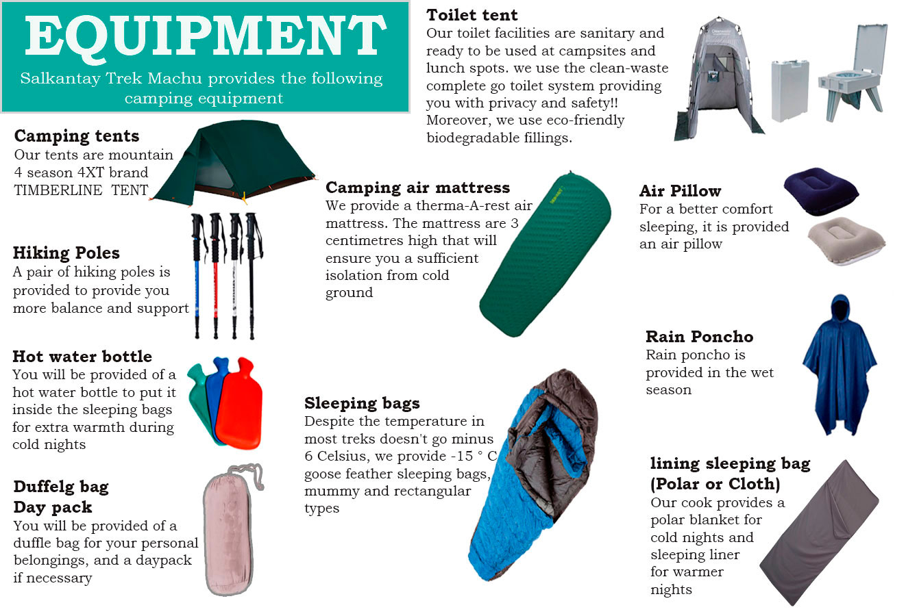
Camping Equipment:
We provide high-quality camping gear, including personal double tents, Term-a-Rest mattresses, tables and chairs, a fully-equipped cooking tent, dining and toilet tents, and bottled gas. For a detailed list of included camping equipment, please refer to our camping equipment inventory.
Day 01: Cusco - Cachora - Playa Rosalina
Day 02: Playa Rosalina - Marampata - Choquequirao
Day 03: Choquequirao - Maizal
Day 04: Maizal - Minas Victoria - Yanama
Day 05: Yanama - Totora
Day 06: Totora - Collpapampa - Wiñaypoco
Day 07: Wiñaypoco - La Playa - Lucmabamba
Day 08: Lucmabamba - Aguas Calientes
Day 09: Aguas Calientes - Machu Picchu - Cusco
The world Choquequirao Trek means the “Cradle of the Gold” in southern Quechua. Its structure and architecture is similar to Machu Picchu and it is even called the “Sister of Machu Picchu”!
Choquequirao is considered as one of the last resistance bastions and refugees of the Incas, who abandoned Cusco in 1535 by order of the Incan ruler Manco Inca to regroup as Cusco was besieged by Spaniards.
Bring your photographic equipment with you as this journey is the most picturesque trip offered in the Cusco’s area! The trip is supported by horses for your convenience and we provide you with top quality camping equipment as well as a very balanced and energetic diet.
Are you hungry for an unforgettable adventure? The Combo Expedition connecting the both Incan highlights, Machu Picchu and Choquequirao, will go beyond your dreams!!!


you will be picked up in your hotel and ridden towards La pampa de Anta, a massive agricultural plain grown with potatoes, maize, etc. Then, the bus journey takes you down into the valley of Limatambo, a narrow fertile valley mainly cultivated with avocado. The trip continues up past the town of Curahuasi, especialist in growing aniseed used to make liquour. You will then take the turn off to Cachora(2,850 m/9,350 ft), a small cattle farming village; driving past the village, you will arrive to capuliyoc (trailhead), this is where you get off the bus and set to leave for the walk. From Capuliyoc viewpoint, there is striking views of the river canyon of Apurimac, the faraway mountains and the Inca site of Choquequirao perched on top of a mountain. The trail winds down the mountain into the river canyon of Apurimac. The weather is very warm and humid which makes to grow special vegetation such as native trees Lambram, chachacomo, inkallaulli, cedar, etc, and also ferns orchids, bromeliads, etc. The typical fauna inhabiting this area are deer, spectacled bear(the only south american bear in endangered), foxes, skunks, etc and also birds for instance; the largest flying bird The Andean Condor, hummingbrids, etc. After Lunch taken at a small oasis-like settlemnt named Chiquisca, you will continue down to Playa Rosalinas(1,550 masl/5,115 ft) and go over a suspension bridge above Apurimac river. From the other end of the bridge, the trail slopes steeply up to Santa Rosa Baja (a small settlement), and as you ascend an make stops, you are rewarded with amazing views of the surrounidng scenery. Campsite in Santa Rosa Baja.
Estimated trekking time: 7-8 hours
Trekking distance: 13 km
Max. elevation: 3,100mt (10170ft)
Min. elevation: 1,550 m (5,115 ft)
Climate: Warm
Difficulty: Easy-Moderate

After a nutritious and hearty breakfast, you will continue up to Marampata (2,850 m/9,350 ft) zigzagging up the trail with more amazing and clear views of the surrounding scenic beauty and depth of Apurimac river canyon, main tributary of the Amazon River!. If lucky, you can spot condors soaring above the mountains! and also the spectacled bear hidden in the bush or just sitting on top of the mountain.Arriving in Marampata, you will rest looking out striking views of the faraway mountains and the site of Choquequirao located still in the distance and also enjoy a suculent lunch. After lunch, the trail goes up and down to the site of Choquequirao (3,100 m/10,168 ft)! The site is bigger in extension than the Sancturary of Machu Picchu!. Late afternoon, you will arrive to the site and wander about as you enjoy sunset. Overnight at Choquequirao campsite
Estimated trekking time: 6 hours
Trekking distance: 11 km
Max. elevation: 3,100 m (10,168 ft)
Min. elevation: 2,850 m (9,350 ft)
Climate: Warm as well as cold
Difficulty: Moderate

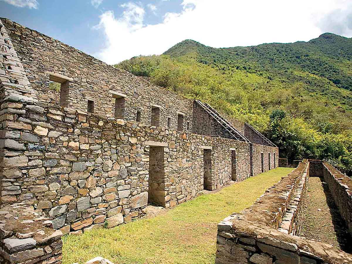
Wake up to the call for a hot drink served in your tent. Following breakfast, you will explore the site of Choquequirao conducted by your guide the whole morning. You will see different neighbourhoods such as the main square with the temple of the sun, Urin (upper neighbourhood) with its open temple, Ushno (ceremonial platform), house of priest, qolqas (storages), irrigation channels and agricultural terraces. Scholars and researchers have not fully found out all the techniques used by the Incas to construct different enclosures. As ypu explore the site, the location of the site and surrounding natural beauty will amaze you.
The Archaeological Park of Choquequirao is located in southern Peru above the right bank of Apurimac River, perched on top of the mountain in the mountain range of Vilcabamba with snow-topped mountain Qoriwayrachina and Padreyoc. The park covers an area of 1,810 hectares.Choquequirao was constructed probably between the second part of the 15th century and the first decades of the 16th century by the time Incas started to conquer new territories in the Antisuyo region (located northwest of Cusco in high Andes inhabited by so called “Antis” – a collective name for the many varied ethnic groups living in this area). Choquequirao is considered as one of the last bastion and refugee of the Incas, who abandoned Cusco in 1535 following order of Inca ruler Manco Inca to regroup as Cusco was besieged by Spaniards. Although, there were a couple of people who visited and wrote about Choquequirao trek to machu picchu, this Inca site had not received a big attention until American historian Hiram Bingham along with the topographer Clarence visited and described the place in 1909!. Due to its location, it probably served as a very important religious centre inhabitted by Inca’s priests. It also served as a big political, economic and cultural centre. The site was abandoned unfinished according to scholars research
After lunch, you will leave the Inca city of Choquequirao by gently ascending 1 hour to Choquequirao Pass (3,300 m/10,890 ft) and afterwards, you will head down towards Rio Blanco (White River; 1,900 m/6,270 ft) entering a cloud forest area polylepis trees (andean native trees with multi-layered bark), epiphytes plants for instance, bromeliads, orchids, different species of brids as well as water fountains. Cloud forest lush vegetation still covers part of the Inca farming terraces of Pinchiunuyoc (2,487 m/8,160 ft). Campsite at Pinchiunuyoc.
Estimated trekking time: 6 hours
Trekking distance: 5 km
Max. elevation: 3,300 m (10,890 ft)
Min. elevation: 1,900 m (6,270 ft)
Climate: Warm with mosquitoes
Difficulty: Moderate

Today you will continue heading down to Rio Blanco, as you will be losing more altitude the vegetation gradually change into dry Andean forest and amazing views of faraway mountains. Arriving at Rio Blanco, you will enjoy refreshing in the clean Rio Blanco after a long descent in the sun. After lunch, you will climb three hours to the village of Maizal (3,000 m/9,900 ft) where you will stay overnight camping. Before dinner enjoy sunset and views of farwaway imposing mountains.
Estimated trekking time: 7 hours
Trekking distance: 10 km
Max. elevation: 4,150 m (13,695 ft)
Min. elevation: 3,800 m (12,540 ft)
Climate: Warm with mosquitoes as well as cold
Difficulty: Moderate-Difficult

Early in the morning, you will climb to Victoria Pass (4,150 m/13,695 ft). After a 4 hour steep ascent, approaching Victoria Pass, you will hike an incredibly well- preserved stone-stepped Inca trail. On arriving at Victoria pass, you will enjoy absolutely striking views of snow-capped mountains of Humantay (5,700 m/18,700 ft) and Salkantay (6,271 m/20,574 ft), considered by local people as the "guardian spirit of the jungle surrounding mountains and also breathtaking view of Yanama valley. Heading down to the valley of Yanama, you will hike past the Victoria mines, an Inca and later colonial silver mine now abandoned. Finally, you will arrive to the village of Yanama (3,800 m/12,540 ft) where you will stay overnight camping with views of Yanama River below us and Pumasillo snow-topped mountain above us.
Estimated trekking time: 8 hours
Trekking distance: 10 km
Max. elevation: 4,668 m (15,315 ft)
Min. elevation: 3,630 m (11,979 ft)
Climate: Warm with mosquitoes
Difficulty: Challenging

You will climb Yanama Valley passing potato fields and enjoying great views of high mountains and waterfalls.The trail leads you up to the highest pass of this hike -Yanama Pass (4,668 m/15,315 ft). Climbing to the pass offers spectacular views of snowy peaks of Sacsarayoj and Padreyoc Mountains! If you are lucky, you can spot majestic condors flying way above the surrounding mountains. When reaching the pass, you will enjoy striking views of the Andean scenery and see a pile of stones that have been added by visitors to thank to Apus (a mountain god) for a safe journey and good luck! Then, you will head down to Totora Village
(3,630 m/11,979 ft) where our next campsite is located.
Estimated trekking time: 8-9 hours
Trekking distance: 20 km
Max. elevation: 2,850 m (9,348 ft)
Min. elevation: 2,680 m (8,793 ft)
Climate: Warm with mosquitoes
Difficulty: Moderate

Early in the morning you will set out a gentle hike to the town of Collpampa and onwards to La Playa.The lush vegetation offers different species of flowers and trees and birds. Upon arrival to the village of Collpapampa, you will enjoy seeing river canyon of Salkantay. The trail goes past waterfalls, river-crossings, agricultural hamlets of maize, potatoes, passion fruit fields, peach trees, bamboo groves, orchards and coffee plantations providing some perfect birdwatching opportunities (e.g. hummingbirds, woodpeckers). You will walk some untouched paths where strawberries grow at our feet and passion fruits are just above our heads, begonias and purple orchids!. After 4 hours hike, you will arrive to the town of La Playa (2,100 m/6,890 ft) where you will have a break and lunch. Finally, you will hike shortly to the village of Lucmabamba (2,250 m/7,381.89 ft) and set up campsite. In the nearby area from campsite, you will visit coffee plantations and taste arabica coffee and also get familiar with diverse plants cultivated in this area such as banana, mango, papaya, avocado, coca leaf, coffee, etc. This area is also a habitat of spectacled bear, parrots,. woodpecker, hummingbirds, etc.
Estimated trekking time: 6 hours
Trekking distance: 5 km
Max. elevation: 2,250 m (7,382 ft)
Min. elevation: 2,100 m (6,890 ft)
Climate: Warm with mosquitoes
Difficulty: Easy

Today, you will wake up early to enjoy sunrise as you climb to Ahobamba pass. As you ascend the mountain and stop for breaks, the scenery provides some amazing views of a rivey valley of Santa Teresa. The steady ascent to the top of the mountain offers some very nice stops for scenic beauty. From the pass, the trail slopes steeply down to the recently restored Incan site of Llaqtapata (2,650 m/8,694 ft) located at the back of Machupicchu Inca site. The views of the imposing Salkantay mountain!! and Machupicchu are striking not many tourist see. After a guided tour of the Inca Site Then our Tour Guide shows us around the ruins! From there, we are given an opportunity to see the main highlight of South America - Machu Picchu, from an exceptional point of view that a majority of tourists will never see!! Then, we descend easily for 3 hours to the Hydroelectric Plant (Hidroelectrica; 2,050 m/6,726 ft). There, we follow trails and the Vilcanota River leading us to our last campsite in Puente Ruinas (2,042 m/6,700 ft), located at the foothill of Machu Picchu Mountain!
Estimated trekking time: 10 hours
Trekking distance: km
Max. elevation: 2,650 m (8,694 ft)
Min. elevation: 2,042 m (6,700 ft)
Climate: Warm with mosquitoes
Difficulty: Moderate-Difficult

After an early morning breakfast, we hike for 2 hours up to the mysterious city of Machu Picchu (2,430 m/7,972 ft) that we enter for the early morning best photos opportunities! Then our Tour Guide shows us around the Incan city and explains us about its history and purposes. After the guided tour, we have an opportunity to climb up for about 45 minutes to Huayna Picchu, a peak above Machu Picchu that serves to take some panoramic pictures of the Incan city. Then, we are given time off to spend and explore Machu Picchu on our own.
In the afternoon, we return by train to Ollantaytambo (alternatively to Poroy), from where we are taken by van back to Cusco.
Machu Picchu is both, the best and the least known site of the Incas as it is not mentioned in any Spanish conquistador´s chronicle so that contemporary archaeologists can not do anything more than just speculate on its functions. Local Quechuan farmers had known about Machu Picchu for centuries before an 11-year-old boy showed the American historian Hiram Bingham (who was in a search of Vilcabamba) this site on the 24th of July 1911. At that time, all the rest of the world became aware of its existence. However, the site was covered with thick vegetation so Hiram Bingham along with his team returned and within the years of 1912 and 1915 cleared its surface. Over the years, plenty of work has been done on excavating and studying the site. Despite these efforts, many unanswered questions remain.
Estimated trekking time: 1 hour
Trekking distance: 3 km
Max. elevation: 2,430 m (7,972 ft)
Min. elevation: 2,042 m (6,700 ft)
Climate: Warm
Difficulty: Moderate
Choquequirao Camping equipment
Meal budget: Please allow USD 30-50 for meals not included.
Single room: Please note that if you have booked the "Single room" option for this trek, you receive your own single tent for all nights.
Local flights: No local flights are included in the trek´s price!
 +51 84 226 547
 +51 912 891 560
 Av Tupac Amaru PP-10B, Santiago, Cusco, Peru
  info@salkantaytrekmachu.com
 www.salkantaytrekmachu.com