
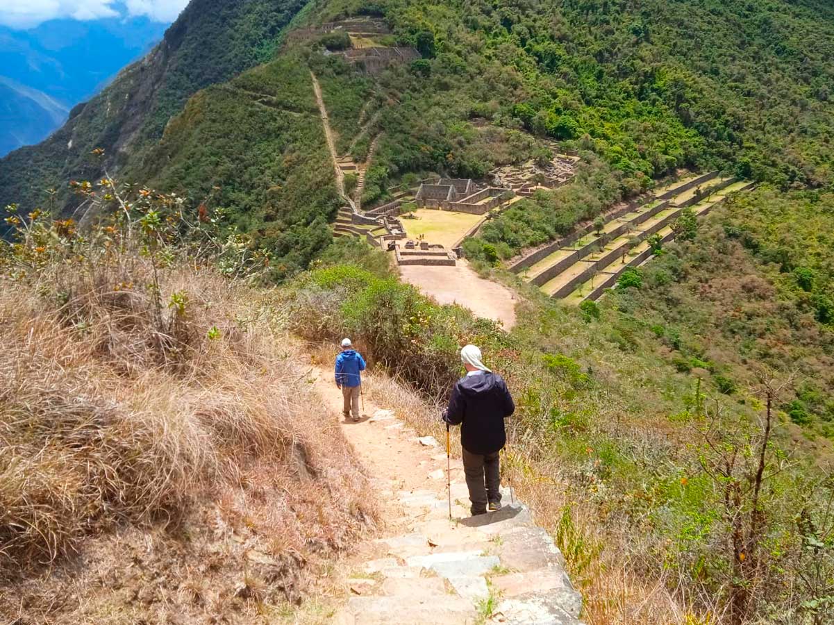
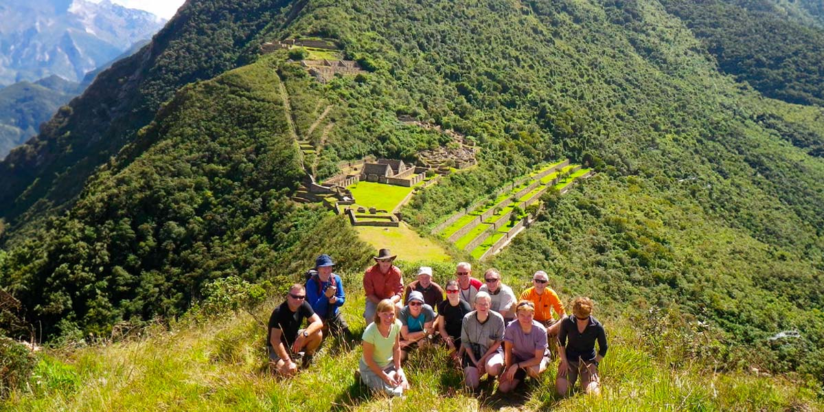
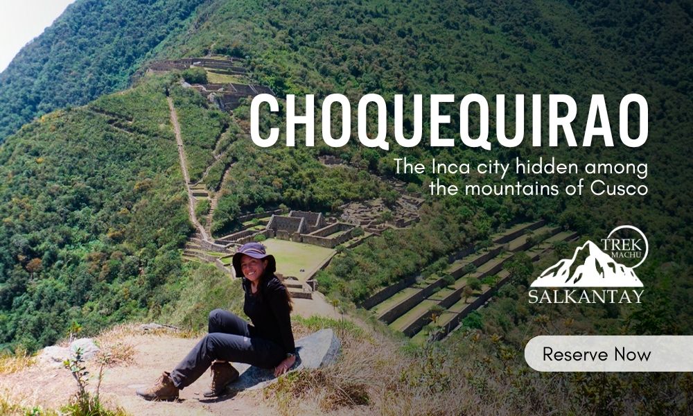
The views during the hike to Choquequirao are impressive. The path crosses a landscape of high mountains, snowy peaks, the Apurimac River, and hillsides covered with vegetation, all at an altitude of more than 2,800 meters. The sky, deep blue and cloudy in parts, frames a setting dominated by the Andean condor, which often soars through the air of this remote valley. Choquequirao, the Inca city known as the "Cradle of Gold", is hidden in the middle of this wild landscape.
Explorer Hiram Bingham discovered Choquequirao in 1909, shortly before reaching Machu Picchu. Today, the site remains hidden among the vegetation, with approximately 80% of its area still covered by the jungle. Choquequirao is not like other accessible destinations. To reach it, you must be prepared for a physical challenge. The hike takes between four and five days, starting from the town of Cachora, about a four-hour drive from the city of Cusco. The landscape changes constantly: rugged mountains, deep canyons, dusty paths, and jungle sections offer a unique experience.
Chronicles and stories indicate that Choquequirao was one of the last Incas' last refuges after the fall of Cusco. After Manco Inca II was defeated by the Spanish, the survivors bravely entered these remote lands to resist the invasion for more than four decades. This history has fueled its legend as "the last Inca city".
Where is Choquequirao located?
Choquequirao, the "sister of Machu Picchu", is perched high in the Apurímac river canyon in the Cusco region, province of La Convención, district of Santa Teresa. It is located over 3,000 meters above sea level in a mountainous area that is part of the Vilcabamba mountain range.
This impressive archaeological complex is surrounded by deep canyons, green valleys, and imposing mountains. It is located about 100 kilometers west of the city of Cusco and more than 60 kilometers in a straight line from Machu Picchu.
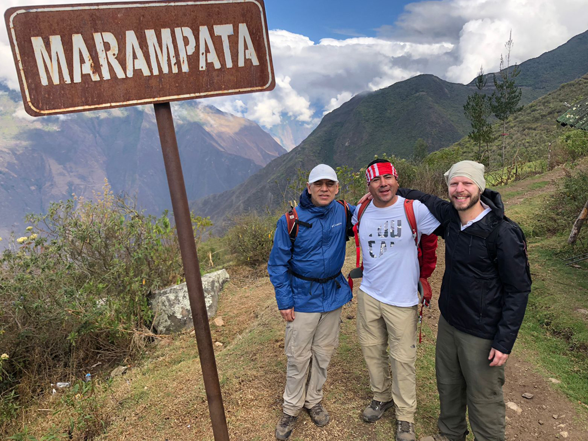
There is no direct vehicular access to Choquequirao. The most common starting point is the town of San Pedro de Cachora, in the province of Abancay, department of Apurímac. The demanding hike from there lasts between four and five days round trip. It crosses spectacular landscapes and steep slopes. There are also alternate routes from Huanipaca or even longer expeditions that connect the Choquequirao to Machu Picchu route.
General Information:
- Location: It is located in the District of Santa Teresa, Province of La Convención, Department of Cusco.
- Climate: Warm temperatures alternate with cold temperatures at night.
- Average temperature: The average annual temperature is a steady 16 °C.
- Season: The climate is defined by the dry season, which typically lasts from April to August.
- Access by land: To access the place, start from Cusco by the road to Abancay. Take the detour to Cachora (2,800 masl) in the department of Apurímac. The journey takes approximately 4 hours. The walk begins here. Some travelers hire muleteers and mules to carry their luggage. The muleteers often act as guides. The entire round trip lasts four days, and you must camp along the way.
- Rate: Adults pay 60 soles and students pay 30 soles.
The weather in Choquequirao
The area's semi-dry temperate climate, with an average annual temperature of 16°C, is a result of its geographic location above the Apurímac canyon. The thermal conditions are contrasting: the days are usually warm due to strong solar radiation, while the nights show a significant drop in temperature. The relative humidity remains high, ranging between 65% and 84%.
When planning your trekking trip, it's essential to understand the three clear periods that define the season.
- Dry season (April to August): It's the most stable time to visit, with clear days and no rain.
- Rainy season (January to March): Expect heavy rainfall that will make access and visibility on the route difficult for several months.
- Transition season (September to December): It features early or occasional rains.
Note: The lower areas of the route, near the river, have a warmer climate and receive more regular rainfall throughout the year.
FLORA AND FAUNA
The Choquequirao Trek is unparalleled in its biodiversity. All these species have been successfully conditioned despite temperature variations, including sunshine throughout the day and inclement frost during the night. The local fauna includes various species of birds and mammals, such as condors, tarucas (Andean deer), vizcachas, foxes, skunks, pumas, hummingbirds, and the national bird of Peru, the cock of the rocks. Its flora is defined by giant ferns, ichu, and a wide variety of orchids, with the wakanki variety being particularly prominent.
Travel Itinerary: 5 Days Challenging the Andes
This challenging tour goes across the Apurímac canyon to reach one of the last places where the Inca resistance is still fighting. Here is the day-by-day route:
Day 01: Cusco – Cachora – Capuliyoc – Playa Rosalina
The trip starts with a pickup in Cusco at 4:00 a.m. for a five-hour drive to the town of Cachora (2892 m), where the hike begins. During the trip, we'll make stops in Limatambo (Tarawasi archaeological site) and Saywite Stone.
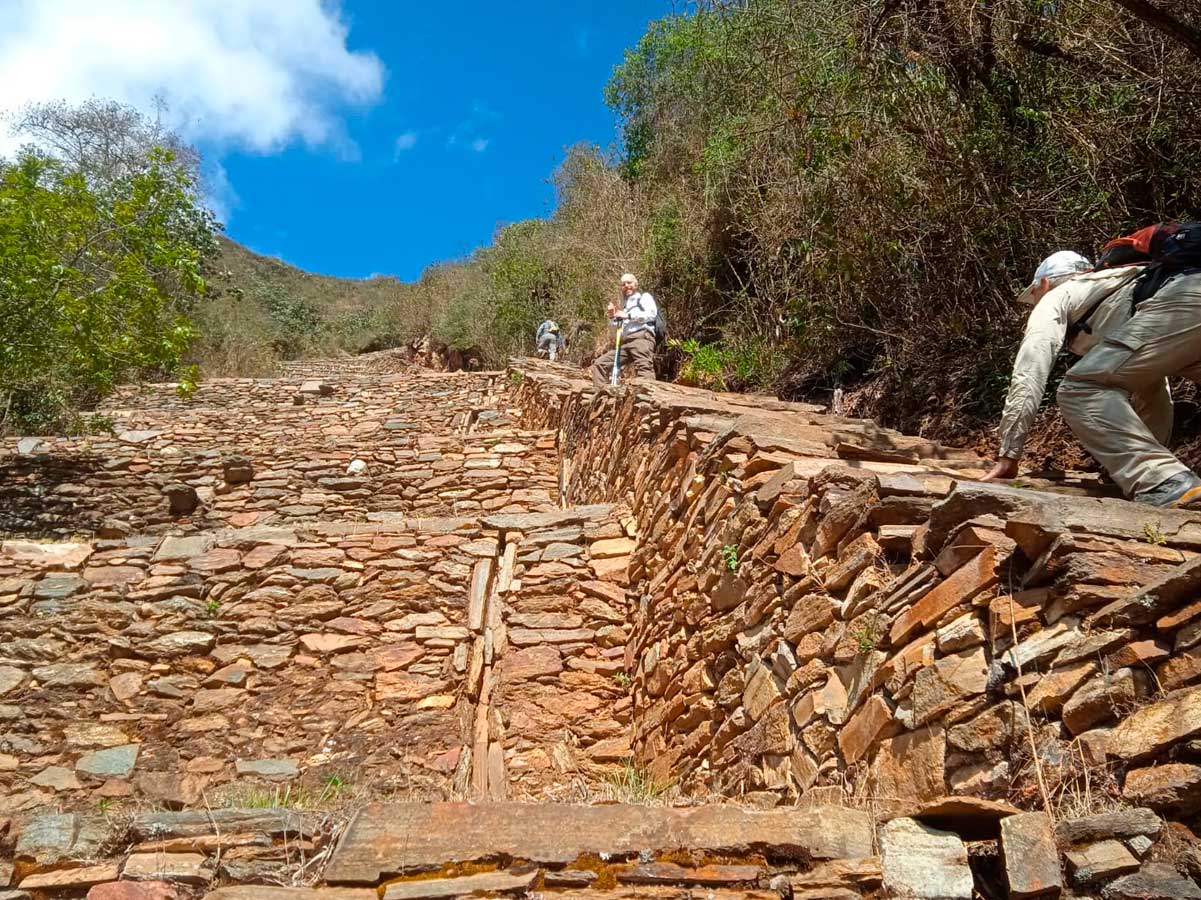
- The hike: From Cachora, you'll slowly go up for two hours to the Capuliyoc viewpoint (2,915 m). There, you'll see the Apurímac Canyon and the snowy peaks of Padrayoc and Wayna Cachora for the first time.
- The Descent: From Capuliyoc, the path goes down into the canyon. It passes through Coca Masana (2,330 m), an area with a warm climate and dry plants. It ends at Playa Rosalina (1,550 m), on the Apurímac River.
- Overnight stay: Camp at Playa Rosalina.
- Food: Lunch and dinner.
Day 02: Playa Rosalina – Raqaypata – Choquequirao
This day of the route is the most demanding because of the significant elevation gain.
- The Ascent: After crossing the river, you will begin a steep climb that will take about five hours to reach the Raqaypata sector, which is next to the Chunchullomayo River. This is where you will have lunch.
- When you get to the site: In the afternoon, the hike continues with a less steep slope for two hours. You will cross areas of orchids and cloud forest until you reach the Choquequirao archaeological site.
- Overnight stay: Camp in the area around the archaeological site.
- Food: Breakfast, lunch, and dinner.
Day 03: Exploration of Choquequirao – Raqaypata
The day is spent exploring the archaeological site. This site was a refuge for the last Incas of Vilcabamba.
- Guided Visit: The main areas visited are the Main Square, the terrace system, the ceremonial enclosures, and the famous "Llamas of the Sun" on the agricultural terraces.
- Return: At the end of the afternoon, we head back to the Raqaypata sector.
- Overnight stay: Camp in Raqaypata.
- Food: Breakfast, lunch, and dinner.
Day 04: Raqaypata – Apurímac River – Coca Masana
The return trip starts with another descent to the bottom of the canyon.
- The route: Then, we will go down a steep path from Raqaypata to the Apurímac River for lunch. Later, you will climb up the opposite side of the canyon for four hours until you reach Coca Masana.
- Overnight stay: Camp in Coca Masana.
- Food: Breakfast, lunch, and dinner.
Day 05: Coca Masana – Cachora – Cusco
This is the last part of the hike. It will take you to the place where you can get the bus back.
- The Hike: The path goes across the middle of the canyon. You can see views from Wayna Qalli until you finally reach the town of Cachora.
- Transfer: We're getting on the bus to go back to Cusco.
- Food: Breakfast and lunch.
The Archaeological Complex of Choquequirao is a site of great historical importance
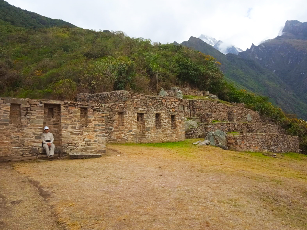
For archaeological research, the site has been divided into 12 sections, labeled with Roman numerals from north to south. The monument at Choquequirao Trek has a main square with platforms and enclosures around it. There are buildings called kanchas and enclosures associated with water sources called Qolqas.
- SECTOR I: The upper square, also called Hanan Square, is a two-level structure next to the entrance of the main water channel, the Ch'unchulmayu River. Here, you can find the main temple, ceremonial fountains, channels, and a medium-sized Kallanka. In the lower part, there is a small patio and two rooms that face each other.
- SECTOR II: is a group of buildings in the Qolqas area. These buildings are long and thin, and they are arranged in a line on two levels and on platforms. There are five buildings on each platform. There is a water source on the left side. There are 16 platforms for experimental culture, especially for ceremonies. This area is used to make metallurgical and ceramic objects. It also serves as housing for the craftsmen and storage for the products.
- SECTOR III: The plaza is the most central and wide part of the complex. On the north side, there are Kanchas with flatlands. The temple of Urin is next to them. There are also two precincts of priests or twin sunturhuasis next to the temple. There's a rectangular Kallanka in this sector. It was used to house visitors or travelers. But there's another idea about its purpose. It could have been a place where the people who lived there would meet.
- SECTOR IV: This sector is made up of buildings located to the south of the central square. The buildings have two sections and an interior layout that resembles a labyrinth. This area is known as Urin Lower Square. There is also a temple in Urin Double Jamb that has windows and doors leading to niches inside the temple.SECTOR V.- A platform with irregular circular walls called Usnu, located on a small hill whose shape was changed to create its surface.
- SECTOR VI: This is a group of enclosures and structures found at the southern end of the complex. Simple courts and two enclosures are connected by a set of platforms. This area is also known as the priests' sector, which is made up of two precincts.
- SECTOR VII: This sector has platforms divided by stairs. These platforms are for farming, and they are for the nobility. The platforms are large and have three terraces. They are 15 meters long and 10 meters wide. The walls are 4 meters high.
- SECTOR VIII: This is the part of the llamas that has a style very different from the Inca constructions. It seems to be a style from the Chachapoyas culture.
- SECTOR IX: Pikiwasi, where weavers lived, shows the many types of yarn and their tools, like pyres and spinning wheels made from camelid bones. These are just guesses based on the research.
- SECTOR X: is the area of the set that is located towards the southeast. It contains agricultural platforms that have not been altered. These platforms are located in the Ch'unchulmayu river canyon.
- SECTOR XI: This is the area of Phaqchayoq that is being developed as part of the Copesco plan. It is also the area of Pinchiunuyoc, which is located on the Blanco River slope. These areas were previously used for agriculture, as confirmed or explained by later investigations.
- SECTOR XII: is an area with residential platforms and agricultural production on the slope of the Blanco River, which is accessible via Yanama. The Phaqchayoq sector has two subsectors. One of them is the agricultural platforms. The other one is the House of the Waterfall or the Waterfall.
Here are some tips for your trip to Choquequirao
Visiting Choquequirao is a unique but demanding experience. Depending on the pace and itinerary, the round-trip hike can last between four and five days, so good preparation is key to enjoying it to the fullest. Here are the most important recommendations:
- Good physical condition: Physical endurance is essential, as the route includes intense ascents and descents, narrow sections, and long days of walking in the sun. It is recommended that you train beforehand with multi-day hikes or cardiovascular exercises.
- Pack light: Pack only the essentials. A light backpack will make the hike much more bearable. Prioritize light, quick-drying clothing; a headlamp; sunscreen; a reusable water bottle; energy snacks; and a basic first-aid kit.
- Camping gear: Since there are no lodgings along the route, you will need to bring a tent, a sleeping bag suitable for low temperatures (especially at night), a thermal pad, and utensils to prepare food.
- Hire a guide or tour: Although you can do the route on your own, many people choose to hire organized tours, which include transportation, guides, pack mules, and food. This makes the experience easier and allows you to focus on your surroundings.
- Avoid the rainy season: The best time to hike is between April and October. During the rainy season (November to March), the paths become slippery and dangerous, and landslides may occur.
- Prior acclimatization is advisable: Since Choquequirao is located more than 3,000 meters above sea level, it is advisable to spend a few days in Cusco or similar areas beforehand, to allow your body to acclimate to the altitude.
- Respect the environment: This archaeological center is a sacred, historical site surrounded by nature. Do not leave trash, remove stones or plants, or damage the archaeological structures.
Reasons Why This Trek Is Worthwhile
When planning a trip to Peru, popular choices include the famous Inca Trail, the cultural tour through Lares, and the route to Machu Picchu. However, if you're seeking a more challenging, authentic, and unconventional experience, the hike to Choquequirao—either on a direct route or as part of the trek to Machu Picchu—offers compelling reasons to choose it.
- Impressive ruins without crowds: Unlike Machu Picchu, Choquequirao receives very few visitors per day. This allows you to explore its wide terraces, temples, and plazas in silence, surrounded only by nature and mountains.
- It's an authentic experience: There are no trains or roads that lead to Choquequirao. Getting there requires physical effort and commitment, making this hike a genuine adventure far from conventional tourism.
- The diverse and spectacular landscapes: The route crosses the Apurímac Canyon and passes through humid forests, dry areas, and high-altitude passes. The views constantly change, offering glimpses of snow-capped mountains, deep rivers, and green ravines.
- Physical challenge and personal achievement: The Choquequirao trek is demanding, involving descents and ascents of over a thousand meters. For many, reaching the summit after several days of hiking is one of their greatest personal achievements.
- A deep connection with Inca history: Choquequirao was an important political and ceremonial center. Its remains demonstrate Andean engineering and vision, and new structures covered by vegetation continue to be discovered.
- It is a destination that remains intact: Mass tourism has not yet arrived. Exploring Choquequirao now offers a unique opportunity for an exclusive experience before the installation of a cable car makes access easier in the future.
The hike to Choquequirao is not easy, but that very difficulty is what makes it one of the most valuable routes for trekking, history, and adventure lovers in Peru.
The Best Machu Picchu Tours
A visit to Machu Picchu is a unique experience where you can see spectacular landscapes and learn about the history and culture of one of the seven wonders of the world. There are multiple ways to reach this wonder, each offering a different level of adventure and charm. To help you choose, here are the most popular tours:
 +51 84 226 547
 +51 912 891 560
 Av Tupac Amaru PP-10B, Santiago, Cusco, Peru
  info@salkantaytrekmachu.com
 www.salkantaytrekmachu.com


